Disclosure: this guide contains affiliate links. If you book or buy through them we may earn a small commission at no extra cost to you, which helps keep Uncover the Andes independent.
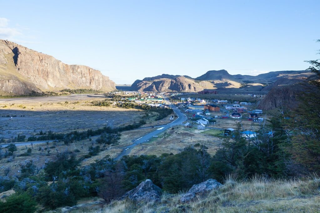
Some mountain towns grow around a ski lift or a mine. El Chaltén grew around a trailhead. Founded in 1985 at the northern edge of Los Glaciares National Park, this small village in Argentine Patagonia now calls itself the national trekking capital, and for once the slogan is not an exaggeration. You can walk out of your hostel door, cross the street and be on a trail that ends beneath Mount Fitz Roy, one of the most dramatic granite spires on the planet. No shuttle, no guide and, until recently, no ticket.
That last part has changed, and so have a few other things. Since the 2024-25 season the park charges an entry fee at the Chaltén portal, the backcountry campsites need a reservation, and prices in Argentina keep moving. This guide brings everything together for 2026: the best day hikes ranked by effort and reward, distances and elevation gain, the current park fee, how to get there from El Calafate, when to go, what to pack, a sample itinerary and the questions hikers ask most before their first trip. If you are planning the rest of southern Patagonia too, keep our El Calafate and Perito Moreno Glacier guide open in another tab.
Why El Chaltén Is the Best Hiking Base in Patagonia
Torres del Paine across the border in Chile gets more international attention, but El Chaltén has three advantages that matter to independent hikers. First, almost every classic trail starts in town, so you do not need park buses, catamarans or expensive refugios to see the highlights. Second, the trails are well marked, well maintained and easy to follow without a guide in good weather. Third, you can design your own trip. One person might do three big day hikes and fly home; another might camp at Poincenot to catch sunrise at Laguna de los Tres, then add Loma del Pliegue Tumbado on a clear day.
The other reason is the scenery itself. From a single valley you see two of the most famous mountains in South America: Fitz Roy (3,405 m), called Chaltén, the smoking mountain, by the Tehuelche people because clouds often hang from its summit, and Cerro Torre (3,128 m), the slender needle that climbers spent decades arguing about. Add hanging glaciers, turquoise lakes, lenga beech forests that turn red in autumn and the occasional Andean condor, and you have a landscape that justifies the long trip south.
El Chaltén Park Fee and Rules in 2026
For decades the trails around El Chaltén were free. That ended in the 2024-25 season, when Argentina’s National Parks Administration began charging entry at the northern zone of Los Glaciares National Park, known as the Portal El Chaltén. The fee applies to the main trail network, including Laguna de los Tres, Laguna Torre and Loma del Pliegue Tumbado.
Under the national park rate update that took effect on 1 June 2026, the general rate for the northern zone of Los Glaciares is ARS 50,000, the rate for Argentine nationals is ARS 25,000, and Argentine students pay ARS 15,000. Multi-day passes have been offered in previous seasons, which makes sense if you plan several hikes. Because Argentine prices are adjusted often and the peso keeps moving, treat these figures as a guide and check the official national parks website before you go. You can usually pay online in advance or at the access points, and rangers may ask to see proof of payment on the trail.
Campsite reservations
The free backcountry campsites inside the park, mainly Poincenot (for Laguna de los Tres), Laguna Capri and De Agostini (for Laguna Torre), now operate with reservations and a per-night fee. Spaces are limited in January and February, so book as soon as your dates are firm. Wild camping outside designated sites is not allowed, and campfires are banned everywhere in the park. Patagonian fires spread fast in the wind, and the region still remembers the devastating fires caused by careless visitors in Torres del Paine.
Trail etiquette that rangers enforce
- Stay on marked trails. Shortcuts on the steep sections cause erosion that takes decades to recover.
- Carry out all rubbish, including fruit peel and toilet paper.
- Use the toilets at campsites, and dig a cathole at least 60 meters from water if you have no choice.
- Do not feed foxes or birds, and keep away from huemul deer if you are lucky enough to see one.
- Drones are not allowed in the national park without a permit.
WHERE TO STAY IN EL CHALTÉN
Wake up with Fitz Roy outside
El Chaltén has only a few hundred beds in each price range and they sell out in January and February. Compare hostels, cabins and lodges with real guest reviews and lock in a refundable room now.
✓ Free cancellation on most stays · ★ Verified reviews · ✓ Hostels to boutique lodges
The Best El Chaltén Hikes at a Glance
Distances below are round trips from the edge of town and times are moving time for a fit hiker with short breaks. Add one or two hours if you like long lunches, photography or slow descents. Elevation figures are approximate and vary by source.
| Hike | Round trip | Elevation gain | Time | Difficulty | Best for |
|---|---|---|---|---|---|
| Laguna de los Tres | 20-24 km | approx. 1,000 m | 8-10 h | Hard (steep final hour) | Classic Fitz Roy close-up |
| Laguna Torre | 18-20 km | approx. 300 m | 6-7 h | Moderate | Cerro Torre and glacier views |
| Loma del Pliegue Tumbado | approx. 20 km | approx. 1,100 m | 7-9 h | Hard | Panorama of Fitz Roy and Torre together |
| Laguna Capri | 8-9 km | approx. 350 m | 3-4 h | Easy to moderate | Short Fitz Roy view, bad weather days |
| Mirador de los Cóndores and Las Águilas | 4-5 km | approx. 250 m | 1.5-2.5 h | Easy | Sunset over town, condors |
| Chorrillo del Salto | 6-7 km | minimal | 1.5-2 h | Easy | Waterfall, rest days, families |
| Huemul Circuit | approx. 60-70 km | several passes | 4-5 days | Very hard, semi-technical | Southern Patagonian Ice Field |
Laguna de los Tres: The Fitz Roy Hike
This is the hike that puts El Chaltén on bucket lists. The trail leaves from the north end of Avenida San Martín and climbs steadily for the first hour to a viewpoint over the Río de las Vueltas valley. From there it rolls through lenga forest and open meadows, passes the side trail to Laguna Capri and reaches the Poincenot campsite and the Río Blanco after about three to four hours.
Then comes the part everyone talks about. The final section gains roughly 400 meters in about a kilometer on loose rock and dirt, with switchbacks that feel endless on a hot afternoon or in strong wind. Most people need 45 minutes to an hour and a half. When you crest the moraine, the view opens all at once: the turquoise Laguna de los Tres directly below the vertical walls of Fitz Roy, with Laguna Sucia hidden in a gorge to the left. Walk a few minutes along the left side of the lake for the best viewpoint over the lower lagoon.
Tips for Laguna de los Tres
- Start early. Leaving town at 6:00 to 7:00 gives you calmer air, cooler temperatures on the climb and the best chance of seeing the summit before afternoon clouds build.
- Check the wind forecast. Rangers sometimes close the final climb when gusts are dangerous. Respect the closure; people have been blown off their feet on the ridge.
- Sunrise option. Camp at Poincenot (with a reservation) and climb in the dark with a headlamp to see Fitz Roy turn orange at dawn. Our El Chaltén and Fitz Roy photography guide covers timing and camera settings.
- Add Piedras Blancas. On the way back, a short detour leads to a viewpoint over the Piedras Blancas glacier, adding about 4 km in total.
- Alternative start. Some hikers take a transfer to Hostería El Pilar, 17 km north of town, and walk the Río Blanco valley in, returning to El Chaltén on foot. It creates a one-way traverse with different views.
Laguna Torre: Cerro Torre and the Glacier
If Laguna de los Tres is the hardest classic, Laguna Torre is the most rewarding effort-to-view ratio in the park. The trail starts at the western end of town, climbs for the first kilometer or two and then follows the Fitz Roy River valley with only gentle ups and downs. After about two hours you reach the Mirador Cerro Torre, where the needle appears at the end of the valley if the clouds allow.
The trail ends at a moraine above Laguna Torre, a gray glacial lake often dotted with small icebergs from the Grande Glacier. Cerro Torre, Torre Egger and Cerro Standhardt rise behind it. If you still have energy, follow the trail along the northern shore for roughly an hour to Mirador Maestri, which looks straight down onto the glacier. In strong west wind the lake can be bitterly cold, so carry a warm layer even in summer.
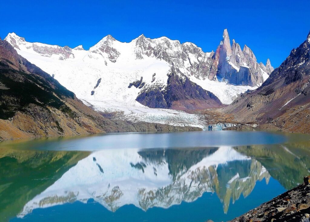
Laguna Torre is the best choice for a first day while your legs adjust, and it is a reasonable option on days when Fitz Roy is hidden but the Torre valley is clearer. The De Agostini campsite near the lake requires a reservation.
Loma del Pliegue Tumbado: The Panoramic Hike
Loma del Pliegue Tumbado is the hike locals often recommend to people who have already done the two lagoons. The trail starts at the national park visitor center at the entrance to town, climbs through forest and then across open slopes to a ridge at around 1,500 meters. From the top you see Fitz Roy, Cerro Torre, Lago Viedma and the Viedma Glacier in a single sweep, a view that neither of the lagoon hikes offers.
It is a long, steady climb with about 1,100 meters of gain and little shade. The final section crosses exposed scree where wind can be extreme, so turn around at the lower viewpoint if conditions deteriorate. Choose a clear, calm day for this one; on a cloudy day you will see nothing at all from the summit.
GLACIERS, BOATS AND GUIDED TREKS
Add the ice to the granite
Pair your El Chaltén hikes with a glacier boat trip, a Perito Moreno visit or a guided trek. Book with free cancellation up to 24 hours before on most activities, with reviews from travelers who did them last season.
✓ Free cancellation on most tours · ★ Traveler reviews · ✓ Local operators
Shorter Hikes and Rest-Day Walks
Laguna Capri
Laguna Capri sits on a side branch of the Laguna de los Tres trail, about two hours from town. On a clear morning the lake reflects Fitz Roy almost perfectly, and it is a fine alternative if you do not want the steep final climb to Laguna de los Tres. Many hikers make a loop: up the main trail, across to Capri and down the alternative path back to town.
Mirador de los Cóndores and Mirador de las Águilas
These two viewpoints start next to the visitor center and take just over an hour for the condor viewpoint and a bit more if you continue to Las Águilas, which looks east over Lago Viedma. They are perfect for your arrival afternoon, for sunset, or for a day when legs are sore. Condors often ride the thermals above the cliffs.
Chorrillo del Salto
A flat, easy walk north of town leads to a 20-meter waterfall in the forest. It is outside the main fee area on some maps, but rules change, so carry your park ticket. It is the most popular walk with families and a good option on a rainy day.
Lago del Desierto and Glaciar Huemul
Thirty-seven kilometers north of El Chaltén, along a gravel road, Lago del Desierto is a long forest-fringed lake with views of the north face of Fitz Roy. Shuttles and tours run in summer, and you can walk to the Huemul Glacier viewpoint, which is on private land with its own small cash fee. A boat crossing of the lake links to a remote border path into Chile toward Villa O’Higgins, a classic adventure route for cyclists and hikers that needs planning around boat schedules.
Multi-Day Treks: Camping and the Huemul Circuit
Most visitors base themselves in town, but camping in the park adds sunrise views without the long approach. A popular two to three day route links Laguna Torre and Laguna de los Tres through the Madre e Hija trail: hike to De Agostini, cross to Poincenot the next day, climb to Laguna de los Tres for sunrise and return to town. You need reservations for each campsite and a stove, since fires are prohibited.
The Huemul Circuit is a different level. This four to five day loop climbs over Paso del Viento to a viewpoint over the Southern Patagonian Ice Field, one of the largest bodies of ice outside the poles, and descends to Lago Viedma. It includes river crossings by tyrolean traverse, which means you must carry a climbing harness, carabiners and the knowledge to use them, plus navigation skills in poor visibility. Registration with the park is mandatory. Do not attempt it as your first Patagonian trek; local guiding companies run it with equipment included.
How to Get to El Chaltén
El Chaltén has no airport. The gateway is El Calafate, about 215 km to the south, with flights from Buenos Aires, Bariloche and Ushuaia. From El Calafate airport most people take a transfer into town and the bus north the next morning, or connect directly in high season.
| Route | How | Time | Approx. cost (2026) | Notes |
|---|---|---|---|---|
| El Calafate to El Chaltén | Scheduled bus | about 3 h | approx. USD 25-45 one way | Several daily departures in summer, fewer in winter |
| El Calafate airport to El Chaltén | Private transfer or rental car | about 3 h | approx. USD 200-300 per vehicle | Paved road, fuel stop at La Leona |
| Buenos Aires to El Calafate | Domestic flight | about 3 h 15 min | approx. USD 80-250 | Book early for December to February |
| Bariloche to El Calafate | Domestic flight | about 2 h | approx. USD 90-220 | Seasonal; check schedules |
| Puerto Natales (Chile) to El Calafate | Bus over the border | 5-7 h | approx. USD 40-60 | Bring passport; then bus on to El Chaltén |
The bus
stops at La Leona, a historic roadside inn where Butch Cassidy and the Sundance Kid are said to have stayed. On the way north, the first view of the Fitz Roy massif across Lago Viedma is one of the best road views in Argentina, so sit on the left side going north. Check our Argentina entry requirements guide before crossing from Chile.
FLIGHTS TO EL CALAFATE
Fly south for less than you think
Domestic fares to El Calafate swing wildly by date. Compare every airline in one search and set a price alert so you book on the cheapest day, not the most expensive one.
✓ Free price alerts · ✈ All airlines in one search · ✓ No booking fees
Best Time to Hike in El Chaltén
The hiking season runs from October to April, with the warmest and longest days in December, January and February. In midsummer you have daylight from around 5:30 to after 22:00, which gives enormous flexibility for long hikes. It is also the busiest and most expensive period, and the windiest. March and April bring fewer people, cooler air and the famous autumn colors when the lenga forests turn red and gold, usually peaking in early to mid April.
| Period | Weather | Crowds | Pros | Cons |
|---|---|---|---|---|
| October-November | Cool, variable, snow possible high up | Low to medium | Quiet trails, spring flowers, lower prices | Some services still opening, unstable weather |
| December-February | Warmest, longest days, very windy | High | All services open, long daylight | Highest prices, campsites full, strong wind |
| March-April | Cooler, calmer on many days | Medium | Autumn colors, softer light, fewer people | Shorter days, first snow by late April |
| May-September | Cold, short days, snow | Very low | Solitude, winter landscapes | Many hotels and restaurants close, trails icy |
Weather changes fast at any time of year. A blue morning can turn into horizontal rain by lunch. The best strategy is flexibility: give yourself at least four nights so you can match the big hikes to the clear days. Check local forecasts that include wind gusts, and ask at the visitor center the evening before.
What to Pack for El Chaltén Hikes
You do not need specialist gear for the day hikes, but you do need to take the wind and cold seriously. A sunny 18 degrees in town can feel like zero at Laguna de los Tres with a 60 km/h wind blowing off the glacier.
- Waterproof hiking boots with good grip for the loose final climbs. See our tested picks of the best waterproof hiking boots for Patagonia.
- A windproof and waterproof shell jacket with a hood. This is the single most important item.
- A warm insulating layer, ideally a light down or synthetic jacket. Our guide to the best insulation jackets for Patagonia compares options.
- Merino base layers, gloves, a warm hat and a buff for the wind.
- Trekking poles, which save your knees on the steep descent from Laguna de los Tres.
- Sunscreen, sunglasses and lip balm. The ozone layer is thin over southern Patagonia and UV is strong even on cloudy days.
- Water and food. Streams on the main trails are generally clean, but many hikers filter to be safe. There is nothing to buy once you leave town.
✓ Gear we recommend
TrailBuddy collapsible trekking poles
The descent from Laguna de los Tres is steep, loose and long. A pair of light aluminum poles with cork grips takes a lot of strain off knees, helps in strong gusts and packs down for the flight south. A popular budget choice with thousands of reviews.
As an Amazon Associate we earn from qualifying purchases.
Sample 4-Day El Chaltén Itinerary
- Day 1: Morning bus from El Calafate. Afternoon walk to Mirador de los Cóndores and Las Águilas, then pick up park tickets and check the forecast.
- Day 2: Laguna Torre, with the extension to Mirador Maestri if the weather is good.
- Day 3: Laguna de los Tres on the clearest day of your stay, starting at dawn. Detour to Laguna Capri on the way down.
- Day 4: Loma del Pliegue Tumbado if it is clear, or Chorrillo del Salto and a café afternoon if it is not. Evening bus back to El Calafate.
With two extra days, add Lago del Desierto or the camping traverse via Madre e Hija. Many travelers then cross to Chile for the Torres del Paine W Trek, which pairs naturally with El Chaltén on a two-week Patagonia trip.
Costs, Money and Practical Tips
El Chaltén is not a budget town by South American standards, because almost everything is trucked in from far away. Expect prices similar to or slightly higher than El Calafate. Since late 2023 foreign credit and debit cards in Argentina are charged at a rate close to the parallel market rate, which has made card payments far more attractive than in the past. Still, the town has only a couple of ATMs, they run out of cash in high season, and some small businesses prefer cash, so arrive with some pesos or US dollars.
| Expense | Budget | Mid-range | Comfort |
|---|---|---|---|
| Bed per night | Hostel dorm approx. USD 25-40 | Private room or cabin approx. USD 80-140 | Lodge approx. USD 200+ |
| Food per day | Supermarket and packed lunches approx. USD 20-30 | Restaurants approx. USD 40-60 | Fine dining approx. USD 80+ |
| Park fee | ARS 50,000 general rate | ARS 50,000 | ARS 50,000 |
| Transport from El Calafate (return) | Bus approx. USD 50-90 | Bus approx. USD 50-90 | Private transfer approx. USD 400+ |
More …
- Mobile signal in town is decent, but there is little or none on most trails. Download offline maps before you go.
- Wi-Fi is slow everywhere, so do not plan remote work here.
- Supermarkets are small and pricier than El Calafate. Some hikers bring snacks and dehydrated meals from El Calafate.
- Book dinner reservations in January and February; popular breweries and restaurants fill early.
TRAVEL INSURANCE FOR TREKKERS
Hike hard, but stay covered
Twisted ankles on the Laguna de los Tres descent are the most common rescue call in the park. SafetyWing covers medical emergencies across Argentina and Chile with flexible plans you can buy even after you have left home.
✓ Covers 180+ countries · ⚕ Medical emergencies · ✓ Cancel anytime
✓ Guidebook we use
Moon Patagonia: National Parks in Argentina and Chile
A detailed guide to Los Glaciares, Torres del Paine, the Carretera Austral and Tierra del Fuego, with trail descriptions and road-trip routes that are useful when you have no signal on the trail.
As an Amazon Associate we earn from qualifying purchases.
El Chaltén Hiking FAQs
Do you need a guide to hike in El Chaltén?
No. The main day hikes to Laguna de los Tres, Laguna Torre, Loma del Pliegue Tumbado and Laguna Capri are well marked and done independently by most visitors. A guide is recommended for the Huemul Circuit and for glacier trekking.
How much is the El Chaltén park entrance fee in 2026?
Since 1 June 2026 the general rate for the northern zone of Los Glaciares National Park is ARS 50,000, while Argentine nationals pay ARS 25,000. Prices change often in Argentina, so confirm the current rate on the official national parks website.
How hard is the Laguna de los Tres hike?
It is a long day of 20 to 24 km with about 1,000 meters of gain. Most of the trail is moderate, but the final hour climbs roughly 400 meters on steep, loose ground. Fit hikers manage it in 8 to 10 hours.
Which is better, Laguna de los Tres or Laguna Torre?
Laguna de los Tres has the more famous close-up view of Fitz Roy but is much harder. Laguna Torre is easier and shows Cerro Torre and a glacier lake. If you have time and good weather, do both.
How many days do you need in El Chaltén?
Plan at least three full hiking days, and four or five nights if possible. The extra time lets you wait for clear weather for Laguna de los Tres and Loma del Pliegue Tumbado.
When is the best time to visit El Chaltén?
December to March offers the warmest weather and longest days. Late March and April bring autumn colors and fewer crowds. Many services close between May and September.
Can you camp in Los Glaciares National Park?
Yes, but only at designated campsites such as Poincenot, Laguna Capri and De Agostini, which now require a reservation and a fee. Wild camping and campfires are not allowed.
How do you get from El Calafate to El Chaltén?
Scheduled buses take about three hours on a paved road and run several times a day in summer. You can also rent a car or book a private transfer from El Calafate airport.
Are there ATMs in El Chaltén?
There are only a few and they often run out of cash in high season. Foreign cards are widely accepted at a favorable rate, but bring some pesos or US dollars for small businesses.
Can you see Fitz Roy and Torres del Paine on the same trip?
Yes. El Calafate is about five to seven hours by bus from Puerto Natales, the gateway to Torres del Paine, so many travelers combine both parks in 10 to 14 days.
FLIGHT DELAYED? CANCELLED?
Your Patagonia flight could pay you back
Patagonian winds delay and cancel flights more often than you think. If your connecting flight from Europe or the US was disrupted, AirHelp checks whether you are owed up to 600 EUR in compensation.
✓ No win, no fee · ⚖ Millions of passengers helped · ✓ Free 2-minute check
Final Thoughts: Plan Around the Weather, Not the Calendar
El Chaltén rewards patience more than fitness. The hikes themselves are within reach of most reasonably active travelers, but the views depend on wind and cloud that no one can schedule. Give yourself a few spare days, start early, carry proper layers and you will almost certainly get your moment beneath Fitz Roy.
Start by securing a room in town and your flight to El Calafate, then add the park ticket and campsite reservations once your dates are fixed. For the rest of your trip south, read our Patagonia photography guide and compare cover in our best travel insurance for South America guide before you go.