
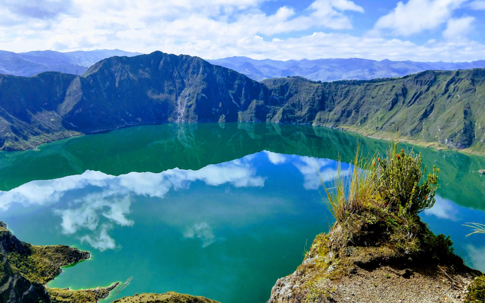
If you only have time for one hike in Ecuador, make it the Quilotoa Loop. Over three or four days you walk between small Andean villages, through deep canyons and patchwork farmland, and finish on the rim of Quilotoa, a volcanic crater filled with an emerald-green lake. There are no permits, no expensive guided tours required and no crowds of the kind you find on the Inca Trail. You simply walk from village to village and sleep in friendly mountain hostels that serve home-cooked dinners by the fire.
A couple of hours south lies Baños, Ecuador’s adventure capital, squeezed into a valley beneath the active Tungurahua volcano. It is the perfect place to rest your legs in hot springs, swing over the edge of the world at the Casa del Árbol, or cycle the Waterfall Route down towards the Amazon. This guide covers both in detail for 2026: how to get there from Quito, a day-by-day Quilotoa itinerary, costs, accommodation, altitude, safety and the best things to do in Baños.
Quilotoa Loop at a Glance
| Item | Details |
|---|---|
| Route | Sigchos → Isinliví → Chugchilán → Quilotoa (or reverse) |
| Total distance | About 22–26 miles (35–42 km) of hiking |
| Duration | 3 hiking days (4–5 hours per day) + travel days |
| Highest point | Quilotoa crater rim, about 12,840 ft (3,914 m) |
| Difficulty | Moderate; steep canyon descents and climbs |
| Starting point | Latacunga, about 2 hours by bus from Quito |
| Guide needed? | No, but GPS map app recommended |
| Best time | June to September (driest); possible all year |
Why Hike the Quilotoa Loop?
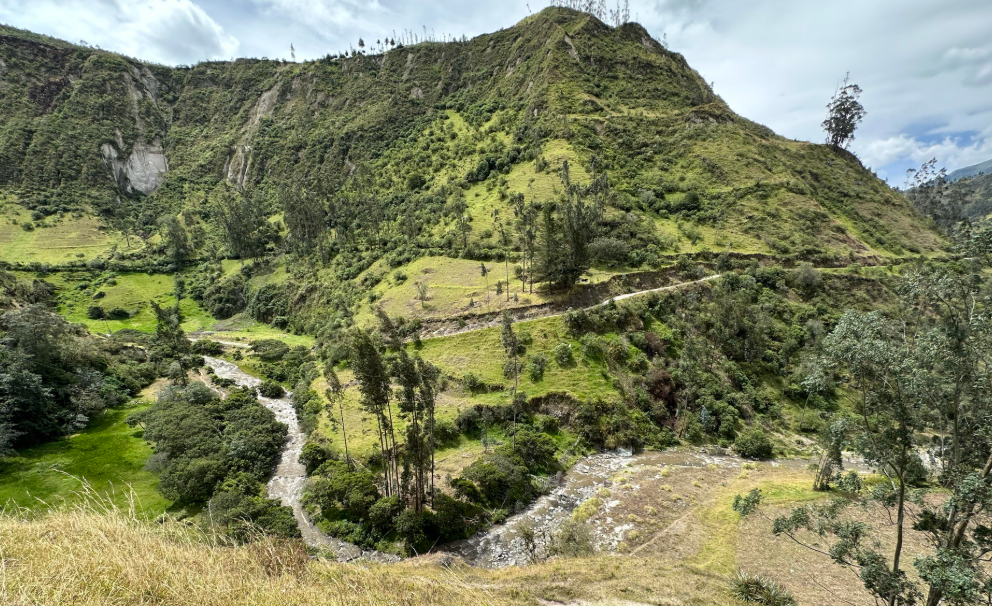
The Quilotoa Loop is one of the best independent multi-day hikes in South America. It combines spectacular scenery with real cultural contact: you pass through Kichwa farming communities, see families working steep fields by hand, and share meals with other hikers in rustic lodges. Because you stay in hostels, you do not need to carry a tent, stove or food, just a day pack with a change of clothes. That makes it accessible to anyone with reasonable fitness.
It is also cheap. Hostels in the villages usually include dinner and breakfast in the price, so you can do the entire loop for well under US$150 including transport. For travelers coming from Peru or Colombia, it is a great introduction to Ecuador’s highlands. If you are new to the country, start with our Ecuador travel guide.
Getting to the Quilotoa Loop from Quito
The gateway to the loop is Latacunga, a small city south of Quito. Buses leave frequently from Quito’s southern bus terminal (Quitumbe) and take around two hours. From Latacunga’s terminal, local buses continue to Sigchos (about 2 hours) if you want to start at the northern end, or to Quilotoa (about 2 hours) if you want to start at the crater.
| Route | Transport | Time | Approx. cost |
|---|---|---|---|
| Quito (Quitumbe) → Latacunga | Intercity bus | ~2 h | US$2.50–3 |
| Latacunga → Sigchos | Local bus | ~2 h | US$2.50–3 |
| Latacunga → Quilotoa | Local bus | ~2 h | US$2.50–3 |
| Quilotoa → Latacunga | Local bus or shared truck | ~2 h | US$2.50–5 |
| Latacunga → Baños | Bus via Ambato | ~2–2.5 h | US$3–4 |
| Quito → Baños (direct) | Intercity bus | ~3.5 h | US$5–6 |
Most hostels in Latacunga let you store your big backpack for free or a small fee while you hike, so you only carry a day pack. Spend the night before in Latacunga so you can catch an early bus. For tips on spending time in the capital before you go, see our Quito travel guide.
Which Direction Should You Hike?
Most hikers walk from Sigchos to Quilotoa, finishing at the crater. This direction keeps the best for last and gets the steepest climb (up to the crater rim) done on fresh legs on the final day, with a big reward at the top. Walking in reverse, starting at Quilotoa, is mostly downhill and easier on the lungs, but the crater comes first and the ending is less dramatic. Either way, you will have long climbs out of the Toachi canyon.
Day-by-Day Quilotoa Loop Itinerary
Day 0: Quito to Latacunga
Take the bus from Quito to Latacunga in the afternoon, store your luggage at your hostel and pick up offline maps. Buy snacks and cash; ATMs are limited on the loop.
Day 1: Latacunga → Sigchos → Isinliví
Catch a morning bus to Sigchos. From the town, the trail descends into the Toachi river valley through farmland and eucalyptus groves, crosses a bridge and then climbs to the village of Isinliví. It is the easiest of the three hiking days, around 7–8 miles (11–13 km) in 4–5 hours. Isinliví is a quiet village with excellent hostels; many hikers say it is their favorite stop.
Day 2: Isinliví → Chugchilán
Day two is longer and more varied, around 7–8 miles (11–13 km) in 4–5 hours. The trail drops into the river canyon again, passes the village of Guantualó, which has a small Monday market, and climbs steeply to Chugchilán. Expect a tough final climb in the afternoon sun. Chugchilán has several lodges with views across the canyon.
Day 3: Chugchilán → Quilotoa
The final and hardest day is about 7–8 miles (11–13 km) and 4–5 hours. You descend into the canyon, cross the river and then face a long, steep climb up to the rim of the Quilotoa crater at nearly 3,914 meters. The first view of the lagoon from the top is breathtaking. Many hikers walk part of the rim before reaching the village of Quilotoa.
Day 4: Quilotoa crater and onward
Spend the morning hiking down to the lake (about 30–45 minutes down and 1–1.5 hours back up) or walking part of the crater rim, which takes four to six hours for the full circuit. In the afternoon, catch a bus to Latacunga and continue to Baños or Quito.
🏨 WHERE TO STAY
Book your stay with free cancellation
Hostels, boutique hotels and Andean lodges with verified guest reviews and flexible bookings in case your plans change.
✓ No booking fees · ★ 28M+ listings · ↺ Free cancellation on most stays
Where to Stay on the Quilotoa Loop
Accommodation on the loop is part of the experience. Most hostels are family-run lodges with shared dining rooms, fireplaces and home-cooked meals. Typical prices include dinner and breakfast, which is a great deal given how remote the villages are.
| Village | Type of accommodation | Price with dinner + breakfast | Highlights |
|---|---|---|---|
| Latacunga | Hostels and simple hotels | US$10–30 (room only) | Luggage storage, bus access |
| Sigchos | Basic guesthouses | US$15–25 | Only if arriving late |
| Isinliví | Mountain lodges | US$20–40 dorm / US$40–70 private | Gardens, hot showers, great food |
| Chugchilán | Lodges and eco-hostels | US$20–45 dorm / US$45–80 private | Canyon views, saunas at some lodges |
| Quilotoa | Community-run hostels | US$15–35 | Crater sunrise, wood stoves |
Book ahead on weekends and in July and August, especially in Isinliví and Chugchilán, where the best lodges fill up quickly.
Navigation: Do You Need a Guide?
The trail is not well signposted. There are some painted arrows and occasional signs, but paths split frequently and landslides sometimes change routes. Download an offline map app with the hiking trails before you start, and ask your hostel for the latest directions; many hand out detailed printed instructions each morning. Local dogs often follow hikers for hours and are, surprisingly, quite good guides.
If you prefer not to navigate, local guides can be hired in each village for around US$30–60 per day, and some agencies in Quito and Latacunga sell organized loops with transport and accommodation included.
🎟 TOURS & ACTIVITIES
Book guided tours with local experts
Day trips, treks and experiences led by licensed guides, with free cancellation up to 24 hours before.
✓ Licensed guides · ★ 10M+ happy travelers · ↺ Free cancellation
Altitude on the Quilotoa Loop
The villages sit between roughly 2,800 and 3,900 meters. If you arrive directly from the coast or from abroad, spend at least two or three days in Quito (2,850 m) first. Climbing out of the canyon at altitude is hard work, so walk slowly, drink plenty of water and avoid alcohol on the first night. The final climb to the crater rim is the moment most hikers feel the altitude. Our article on preventing altitude sickness applies equally to Ecuador.
Quilotoa Loop Budget
| Expense | Budget | Comfort |
|---|---|---|
| Buses (Quito → loop → Baños) | US$12 | US$15 |
| Latacunga night | US$12 | US$35 |
| 3 nights on the loop (with dinner + breakfast) | US$70 | US$190 |
| Lunches and snacks | US$15 | US$25 |
| Quilotoa entrance and small fees | US$5 | US$5 |
| Total (4–5 days) | ~US$115 | ~US$270 |
Ecuador uses the US dollar, which makes budgeting easy. Bring plenty of small bills, as change is often scarce in the villages.
What to Pack for the Quilotoa Loop
- A 25–35 liter day pack.
- Hiking shoes or boots with good grip; trails are dusty and slippery when wet.
- Rain jacket and a warm fleece or down jacket for cold evenings.
- Sun hat, sunglasses and high-SPF sunscreen: the equatorial sun at altitude burns fast.
- Two liters of water capacity and purification tablets.
- Snacks for lunch on the trail.
- Headlamp, toilet paper and hand sanitizer.
- Offline maps and a power bank.
Our guide to the best power banks for Andes trekking helps you keep your phone alive for navigation, and our best travel backpacks guide covers the main pack you will leave in Latacunga.
🛒 GEAR PICK ON AMAZON
30-liter hiking daypack with rain cover
On the Quilotoa Loop you only carry a day pack. A comfortable 30L pack with a hip belt and built-in rain cover is ideal for three days between villages.
Baños: Ecuador’s Adventure Capital
After the loop, head to Baños de Agua Santa, a small town at about 1,820 meters at the edge of the Andes, where the mountains start to fall towards the Amazon. Baños is named after its hot springs and sits beneath the Tungurahua volcano. It is packed with hostels, cafés and adventure agencies, and it is one of the most enjoyable places in Ecuador to spend a few days.
Best things to do in Baños
- Casa del Árbol (the “swing at the end of the world”): a treehouse with a swing hanging over a steep valley with views of Tungurahua on clear days. Go early in the morning for the best chance of clear skies.
- Ruta de las Cascadas by bike: rent a bike and ride downhill along the road towards Puyo, passing a series of waterfalls, cable cars across the gorge and the spectacular Pailón del Diablo, a thundering waterfall you can approach via stairs and tunnels. Most people ride to Río Verde (about 18 km) and take a truck back.
- Hot springs: soak in the thermal pools at the foot of the waterfall in town, especially in the evening or early morning.
- Canyoning and rafting: descend waterfalls with ropes or raft the Pastaza River with local agencies.
- Puenting and ziplining: Baños is famous for bridge swings and ziplines over the canyon.
- Day trip to the Amazon: Puyo and the Amazon rainforest are just over an hour away.
| Activity in Baños | Typical price (2026) | Duration |
|---|---|---|
| Bike rental for Ruta de las Cascadas | US$8–12 per day | Half day |
| Casa del Árbol entrance | A few dollars | 1–2 hours with transport |
| Hot springs | A few dollars | 1–2 hours |
| Canyoning | US$30–50 | Half day |
| White-water rafting | US$30–60 | Half day |
| Amazon day trip from Baños | US$40–70 | Full day |
🛡 TRAVEL INSURANCE
Trek the Andes fully covered
Medical cover built for long trips and nomads, from about $1.60 per day. Sign up even if you are already on the road.
✓ 180+ countries · ⚕ Hospital & emergency cover · ⏱ Cancel anytime
Suggested 7-Day Itinerary: Quito, Quilotoa and Baños
| Day | Plan |
|---|---|
| Day 1 | Quito: historic center, TelefériQo, acclimatization |
| Day 2 | Quito → Latacunga by bus |
| Day 3 | Bus to Sigchos, hike to Isinliví |
| Day 4 | Hike Isinliví → Chugchilán |
| Day 5 | Hike Chugchilán → Quilotoa crater |
| Day 6 | Quilotoa crater morning, bus to Baños |
| Day 7 | Baños: Ruta de las Cascadas, hot springs; night bus or return to Quito |
With more time, add Cotopaxi National Park, the Otavalo market north of Quito, or continue south to Cuenca. For the full country picture, see our Ecuador travel guide.
Best Time to Hike the Quilotoa Loop
Ecuador’s highlands can be hiked all year, but the driest months are June to September, when skies are clearest and trails are firm. October to May brings more afternoon rain and clouds, especially in the canyon, but mornings are often clear. Start early every day to avoid afternoon storms and fog at the crater. Weekends are busier at Quilotoa itself, as Ecuadorian families visit on day trips.
Safety on the Quilotoa Loop and in Baños
The Quilotoa Loop is generally considered safe for hikers, and villagers are friendly and used to visitors. The main risks are getting lost, sunburn, sudden weather changes and steep, slippery descents. Hike in pairs or small groups when possible, start early, and tell your hostel where you are going. In Baños, choose adventure agencies with good reviews and proper safety equipment, and check that your insurance covers activities such as canyoning and rafting.
Ecuador’s security situation has changed in recent years, mostly affecting coastal cities. Read our honest guide to safety in Ecuador before you go, and our guide to the best travel insurance for South America.
✈ FIND CHEAP FLIGHTS
Fly to South America for less
Compare hundreds of airlines and booking sites at once and grab the lowest fare for your dates — including budget domestic hops between Andean cities.
✓ Free to use · 🌍 100M+ travelers monthly · 🔔 Price alerts
Responsible Hiking in Ecuador’s Highlands
The Quilotoa Loop crosses private farmland and community land. Stay on paths, close gates behind you, do not pick crops, and carry all your trash back to the village. Buy snacks, crafts and meals locally to make sure tourism benefits the communities you pass through. Ask before photographing people. Our guide to sustainable trekking in the Andes has more tips.
Extending Your Trip: Cotopaxi, Otavalo and Cuenca
The Quilotoa Loop and Baños are just two of the highlights of Ecuador’s “Avenue of the Volcanoes”, the long highland corridor between two parallel ranges of the Andes. If you have more time, these are the best additions to your route.
Cotopaxi National Park
Cotopaxi, at 5,897 meters, is one of the highest active volcanoes in the world and one of the most perfectly shaped. Day trips from Quito or Latacunga take you to the Limpiopungo lagoon and, conditions permitting, up to the José Rivas refuge at around 4,800 meters, often with an optional downhill bike ride. Several haciendas and lodges around the park make wonderful places to spend a night, with horse riding and views of the volcano at sunrise. Volcanic activity sometimes restricts access to the upper slopes, so check the current situation before you go.
Otavalo market
North of Quito, the town of Otavalo hosts one of the most famous indigenous markets in South America. The main market runs every day, but Saturday is the big day, when the Plaza de los Ponchos overflows with textiles, hammocks, jewelry and leather goods, and an early-morning animal market takes place on the edge of town. Combine it with a hike around the Cuicocha crater lake or the Peguche waterfall.
Cuenca
Ecuador’s third city is a beautifully preserved colonial town and a UNESCO World Heritage Site, with cobbled streets, blue-domed cathedrals and a relaxed atmosphere. It is the gateway to Cajas National Park, a high moorland of hundreds of lakes with excellent day hikes. Cuenca is about seven hours by bus from Baños, or a short flight from Quito.
Common Mistakes on the Quilotoa Loop
- Not booking hostels on weekends. The best lodges in Isinliví and Chugchilán fill up quickly on Fridays and Saturdays.
- Starting too late. Afternoon clouds and rain are common. Be walking by 8:00 am.
- Relying on mobile signal. Coverage is patchy in the canyon; download offline maps before leaving Latacunga.
- Carrying a big backpack. Store your main luggage in Latacunga and hike with a day pack.
- Running out of cash. There are almost no ATMs on the loop, and few places accept cards.
Frequently Asked Questions
How long is the Quilotoa Loop?
The full hike is about 22–26 miles (35–42 km), usually done in three days of 4–5 hours of walking each, from Sigchos to Isinliví, Chugchilán and the Quilotoa crater.
Can I hike the Quilotoa Loop without a guide?
Yes. Most hikers go independently using an offline map app and directions from their hostels. The trail is not well marked, so careful navigation is important.
How do I get to the Quilotoa Loop from Quito?
Take a bus from Quito’s Quitumbe terminal to Latacunga (about 2 hours), then a local bus to Sigchos or Quilotoa (about 2 hours).
How high is the Quilotoa crater?
The crater rim is about 12,840 ft (3,914 m) above sea level. The lake inside sits a few hundred meters lower.
Is the Quilotoa Loop difficult?
It is moderate. Each day has steep descents into canyons and long climbs back out at altitude. Anyone with reasonable fitness who has acclimatized in Quito can do it.
Which direction is best for the Quilotoa Loop?
Most hikers go from Sigchos to Quilotoa to finish at the crater. The reverse direction is easier on the lungs but less rewarding at the end.
How much does the Quilotoa Loop cost?
A budget traveler can do the loop for about US$115 including transport, three nights with dinner and breakfast, and snacks. Comfortable private rooms raise that to about US$270.
Can I swim in Quilotoa Lake?
Swimming is generally discouraged because the water is very cold and the lake is volcanic. You can hike down to the shore and rent a kayak on some days.
How do I get from Quilotoa to Baños?
Take a bus from Quilotoa to Latacunga, then a bus to Baños via Ambato. The total journey takes about 4–5 hours.
What is the best thing to do in Baños?
Cycling the Ruta de las Cascadas to the Pailón del Diablo waterfall is the highlight for most visitors, followed by the Casa del Árbol swing and the hot springs.
Conclusion: Ecuador’s Perfect Andes Combo
The Quilotoa Loop offers what many trekkers dream of: spectacular canyon scenery, a jaw-dropping crater lake, warm village hospitality and the freedom to do it all on your own for very little money. Combine it with a few days of waterfalls, hot springs and adventure sports in Baños, and you have one of the best weeks you can spend in the Andes.
Continue planning with our Ecuador travel guide, our Quito travel guide, and our list of the most beautiful places in the Andes.